Monday, October 20, 2014

Rare Eclipse As Sun Rose


On Wednesday October 8th, The Midwest was treated to a rare eclipse called a blood moon as the sun rose.

The sun rose soon after the total period ended and there was first light already toward the end of the "total" period. The skies were clear, offering a great viewing opportunity to see the moon in the western sky. There was no danger to your eyes so you could have stared as long as you liked.

The total eclipse and the rising sun were in the sky simultaneously for a short period of time, allowing watchers to catch a glimpse of both.

Most often, a lunar eclipse occurs before sunrise. On Wednesday morning, the Earth, while passing between the moon and sun, eclipsed the moon in the process.

This lasted through sunrise.

The moon and sun are often visible in the sky at the same time- so what makes this occurrence special?

During a lunar eclipse, the sun and moon are 180 degrees apart in Earth's sky- with one rising as one sets- which should make it theoretically impossible to see both.


Thanks to a trick of the light, in which the atmosphere bends light at a certain angle near the horizon, an optical illusion will make the sun and moon appear slightly higher in the sky.

Sunday, August 10, 2014

End of July and Lake Superior's water Temp Drops to 38 Degrees, Lake Michigan down to 41 Degrees Some 30 degrees below normal!

 The water temperatures along coastal regions of Lakes Michigan and Superior took an astounding 25 to 30 degree plunge overnight on July 28th. Parts of Lake Superior bottomed-out at 38°F, while parts of eastern Lake Michigan hit 41°F. These temperatures are more common in April than the last week in July.


The water managed to get this cold through upwelling, which occurs when cold waters towards the bottom of a body of water rises towards the surface. WOOD-TV meteorologist Bill Steffen described what caused the upwelling event:

We had a strong north wind behind a cold front and that pushed the surface water toward the middle of the lake, allowing much colder water from 100 feet below to rise to the surface.
The cold water's effect on the weather will remain localized, with cooler temperatures along the coast as well as persistent fog over coastal waters.

As seen by the satellite imagery at the top of this post, the rapidly-chilled water created a thick layer of fog on Lake Michigan where temperatures dropped the most. The cold water cooled the air above it through conduction, dropping the air temperature to its dew point and condensing its water vapor.


The average temperature for Lake Michigan at the end of July is around 68°F, and the average temperature for Lake Superior sits around 60°F.

Thursday, July 3, 2014

RARE JULY WATERSPOUT ON LAKE ST CLAIR

Some pretty incredible photos were taken over Lake St. Clair this morning. An unusually cold air mass aloft over relatively warmer waters cause a rare July waterspout on Lake St. Clair. Temps actually started the day at midnight in the upper 60's but quickly dropped into the mid 50's by late morning. Temps at noon remained in the mid 50s which is some 25 degrees below normal for this time of year. 7-3-14


Great Lakes' Cold Water Temperatures Affect Summer Events

It may sound strange, but some people are changing or even canceling their summer plans because of the lingering effects from this past harsh winter.


Lake Superior and Lake Michigan are much colder than average, thanks to the record ice coverage this past winter. In fact, Lake Michigan is running about 10 to 12 degrees below average this time of year, according to the National Oceanic and Atmospheric Administration. The average surface water temperature for Lake Michigan is currently about 54 degrees, although temperatures have climbed into the 60s in parts of southern Lake Michigan.

Fog in Chicago
One of the consequences of the colder water temperatures is frequent fog. When the warm and moist air meets the cold lake, fog and low clouds often form. Fog was reported in Milwaukee every day from June 16-28. A foggy June has also been reported from Muskegon, Michigan, to Chicago northward to Green Bay and in Duluth, Minnesota.

In Wisconsin, the U.S. Navy Blue Angels were unable to fly the weekend of June 21-22 at the Milwaukee Air & Water Show due to fog. Poor visibility created unsafe flying conditions, according to the event's Facebook page.

The reduced visibility also forced organizers at Summerfest in Milwaukee to postpone the Big Bang fireworks until July 1 due to safety concerns. The fireworks display, originally scheduled for June 24, would have also been difficult for spectators to enjoy with the dense fog.

Heavy fog also suspended a baseball game in Kenosha, and a game in Chicago between the Cubs and Washington Nationals was almost delayed.

On days when fog reduces visibility, it's important for boaters and swimmers to exercise caution, and be wary of the length of time they're exposed to cold water.

Great Lakes Considered Ice Free As of June 8th

It was a seriously cold and icy winter on the Great Lakes, but as of June 8th they're finally ice free at least statistically. A 6/08/14 map from the National Oceanic and Atmospheric Administration's (NOAA) Great Lakes Environmental Research Laboratory shows 0.1 percent ice cover.

Thursday, June 19, 2014

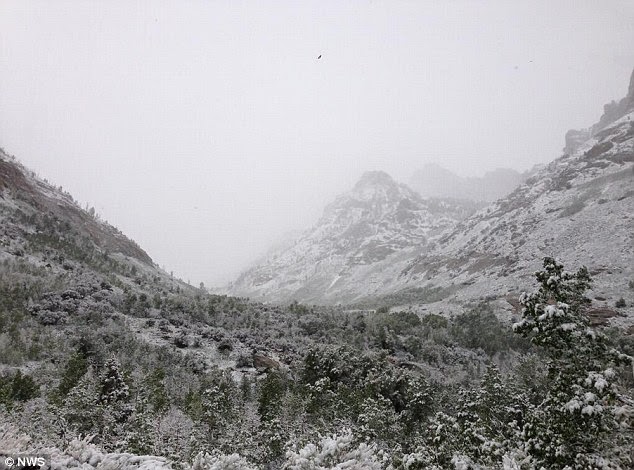
Summer snow shocks parts of the western U.S.

While much of the United States basked in summery temperatures, perplexed residents of Utah, Idaho and Montana woke up to snow yesterday.

Winter just won't quit in the Northern Rockies, where a swirling upper-level low left Alta, Utah with nine inches of snowfall on Tuesday - their third highest one-day snowfall total in June ever.

The snow came as a wave of heavy rain drenched southern Minnesota early Wednesday, flooding streets in Mankato and causing mudslides that forced the closure of some highways.


Meanwhile, Nebraska is still reeling after deadly tornadoes tore through the state, and New Mexico is battling wildfires that threaten to destroy Native American homes, farm land and livestock.


this picture was posted Wednesday morning in kamas, Utah 

Winter just won't quit in the Northern Rockies where an upper-level low was swirling early this week. This picture was taken at Lamoille Canyon in Nevada where 3-4 inches were recorded

A photo provided by Glacier National Park shows the Sperry Chalet in Glacier National Park, Montana on Wednesday June 18


Thursday, June 5, 2014

Mackinac Island Michigan Still Has Snow!

Believe it or not, there’s still snow on Mackinac Island.


“We have the last man standing, I think, in terms of snow piles,” said Bradley McCallum, general manager of Mission Point Resort, where a pile of the white stuff refuses to die.

Tourists and locals have been flocking to the resort to take pictures of the snow pile, which has somehow managed to hold on long after the rest of Mackinac Island emerged from the deep freeze of an especially harsh winter.

Although the snow has obviously been melting, the pile was still more than 3 feet tall on Tuesday, June 3, said McCallum.

The pile is on the south side of the resort’s conference center along Main Street, amid some pine trees. It’s got some shade, and daytime high temperatures on the island aren’t quite as hot as downstate areas — reaching about 70 degrees on average these days — but snow in June is still somewhat logic defying.

“It’s so strange because it’s really nice on the island,” McCallum said. “The streets are full of people and we’re looking forward to a really good season.”

The snow pile is yet another reminder of the harsh winter northern Michigan endured this year. Tourists have been making road trips to the Upper Peninsula recently to see the ice that remains on Lake Superior.

The Great Lakes Environmental Research Laboratory reported that Lake Superior was still about 2.5 percent covered in ice on May 30.

The onslaught of subzero temperatures locked Mackinac Island in a deep freeze that delayed the traditional start of tourist season by several weeks and caused some hardship in transporting people and freight between the island and mainland.

But everything has largely returned to normal in that regard, said McCallum.

Is June a record for snow on the island? It's hard to say, he said. Most believed the snow had all melted on the island a couple weeks ago, but an old 19th century photo circulating among locals shows snow with a June handwritten date on it, indicating this may not be the first time the Straits area has finally thawed long after downstate.

The resort is offering a free night's stay to whoever can correctly guess the date on which the snow pile finally melts, he said.


“I think it’ll be sometime after the 15th,” he said. “It looks small, but there’s still a good chunk of snow there.”