Saturday, December 21, 2013

Ice Storm Warming For South Eastern Lower Michigan

Freezing Rain Is Expected To Develop This Afternoon... Continuing Into Tonight.
Ice Accumulations Of A Quarter Of An Inch To Half An Inch Are Expected.
Northeast Winds Of 10 To 15 Mph Will Add Stress To The Ice Coated Trees And Power Lines. Impacts...
Ice Accumulations On Trees And Power Lines Will Likely Lead To Power Outages As Tree Damage Occurs.
This Ice Storm Has The Potential To Produce Power Outages That Could Last For Several Days.
Expect Roads To Become Icy This Afternoon And Especially This Evening. Precautionary/Preparedness Actions...
An Ice Storm Warning Means Severe Winter Weather Conditions Are Expected Or Occurring. Significant Amounts Of Ice Accumulations Will Make Travel Dangerous Or Impossible. Travel Is Strongly Discouraged. Commerce Will Likely Be Severely Impacted. If You Must Travel...Keep An Extra Flashlight...Food...And Water In Your Vehicle In Case Of An Emergency. Ice Accumulations And Winds Will Likely Lead To Snapped Power Lines And Falling Tree Branches That Add To The Danger.

Storms, Flooding, Ice and Snow: Christmas Travel at Risk

Similar to the days prior to Thanksgiving, the worst weather will focus on the days prior to Christmas as millions of travelers take to the roads and skies in the United States and southern Canada.

According to AAA, 94.5 million people will travel 50 miles or more over the holiday season, spanning Dec. 21 to Jan. 1.


Most of the travel troubles will be caused by a single storm system forecast to affect much of the Central and Eastern states on Saturday and Sunday.

The storm this weekend will bring a wide variety of weather ranging from temperature extremes to heavy snow, ice, flooding rain, fog, severe thunderstorms and the potential for tornadoes. The storm will affect major airport hubs from Dallas to St. Louis, Chicago, Detroit, Atlanta, New York City and Boston.

This is a spring storm stuck in a winter pattern that threatens to combine slippery travel and flight delays with the dangers of flooding and violent thunderstorms.


Rain, Record Warmth Bring Major Flooding Risk to Midwest

A brief, but major shift in the weather pattern will send warm air northward and will produce a zone of heavy rain in parts of the Central and Eastern states this weekend.

Temperatures will trend upward through the end of the week from the Deep South to New England.

By the weekend, temperatures may challenge record highs from the Gulf Coast to the Ohio Valley and the mid-Atlantic.
Highs will be in the 70s over much of the South with a few spots flirting with 80 degrees Saturday and Sunday

Temperatures will reach into the 60s along the Ohio River and the Mason-Dixon line bordering Pennsylvania and Maryland.

The combination of warm, moist air flowing over cold ground and snowcover will lead to locally dense fog in some locations. Fog could hinder early holiday travel this weekend.

Flooding Risk

Enough rain can fall by itself to cause flash, urban and small stream flooding in areas from the northwestern Gulf Coast to the lower Great Lakes and New England.

Where there is still a significant amount of snow remaining on the ground in northern areas, rain combined with warm, moist air can cause that snow to melt rapidly and a substantial rise may result on some rivers.
The situation is being monitored by experts in the National Weather Service and in the commercial weather forecast sector.
The NWS Ohio River Forecast Center is projecting moderate to major flooding along many rivers from southeastern Illinois to northeastern Ohio, including portions of Kentucky.

Monday, December 16, 2013

More Snow For Detroit, Then A Brief Thaw

Another wintry week is in store for Detroit featuring bitter cold, snow accumulation and some icy conditions.
Following the weekend's snowstorm that dropped 7 inches , another round of snow will hit the city late Monday night through Tuesday morning. Snow accumulation in and around the city will be one to two inches come Tuesday morning.

While temperatures will be right above freezing on Tuesday, wind will make it feel even colder. A wind from the west/southwest will be sustained at around 17 mph but gusts up to 33 mph are possible throughout the day.
Winds will subside overnight but into the evening hours gusts up to 20 mph could occur.


At midweek, times of clouds and sun on Wednesday will bring a short-lived relief to the wintry weather for the city. However, it will still be cold in the city, as the day's high temperature will peak at only 26.
It will not be as cold on Thursday but a mix of snow, sleet and freezing rain during the afternoon hours will make for icy conditions around the city. Into the evening hours this mix could cause some traffic delays as roads may freeze.
Those out on the roads Thursday afternoon and evening should use caution as icy, slippery conditions are possible.
Another period of rain will come Friday morning but the air will be warmer on Friday, so the concern for icing will be reduced.

Wednesday, December 11, 2013

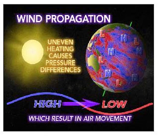
Where do storm systems come from?

Wind movement around the world is caused by uneven heating of the Earth by the sun. This creates high and low pressure areas in various locations across the planet. Air then moves from high to low pressure creating air patterns globally.